
Trending
ST. CLAIRSVILLE -- It was no drill when St. Clairsville's tornado alarm sounded on Saturday -- a funnel cloud touched down and created a 3-mile path of destruction.
This was the second confirmed tornado to strike the area in the past several years, following another in 2021.
Belmont County Emergency Management Agency Director David Ivan said the National Weather Service in Pittsburgh confirmed the Saturday tornado.
"They're the ones who came out and did the site survey," Ivan said, adding that no one was hurt when the tornado touched down.
Meteorologist Jason Frazier reviewed the report.
"Through the afternoon and evening of Aug. 12, we had initially scattered thunderstorms that were strong to severe moving through the area that eventually had a line that moved through the evening hours between 7 and 9 p.m. At about 8:13 p.m., one of these severe thunderstorms was able to generate a tornado that was just north of St. Clairsville. That tornado was rated as an EF-1 tornado with estimated peak wind of about 100 mph," he said.
Frazier said tornadoes are ranked on a scale of 0-5, with five being the strongest.
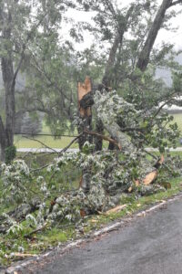
"It's on the lower end of the scale. It can still do some considerable damage, but less than some of the more intense, higher-rated tornadoes," he said. "Based on what they were able to assess and find on what was reported, the tornado seemed to start around Hidden Springs Drive, which is about 3 miles northwest of St. Clairsville with at least three homes that have trees that fell onto them, along with some trees that were completely uprooted. It eventually moved to the east/southeast, knocking or snapping some ... pine trees, and then along Maynard Road it did have a barn that was destroyed."
Frazier said the tornado lifted soon after.
"The total length of the tornado or time it was on the ground from a distance perspective was about 3 miles," he said.
Frazier said the area had not seen any tornadoes yet this year, and it is not unusual for the forecast area of Eastern Ohio, northern West Virginia and western Pennsylvania to have six to eight tornadoes in a year; however there have only been four reported tornadoes in Belmont County since 1950.
"But that's just what's been reported or verified. There could be others in the past that's just never been brought to our attention," he said. "If information wasn't reported to the weather service, we wouldn't have had it documented."
Frazier advised the public to pay attention to tornado watches and warnings.
"Make sure that you have the latest forecast and are monitoring the situation, whether it's through local media, online resources," he said, "having multiple ways to receive those warnings."
He said during a tornado, people should take shelter in a basement or the rear of a home.
Cumberland Trail Fire District Capt. Curtis Kyer was on duty during the tornado. He reported other damage occurred during the storms Saturday.
"We had been called for a caller that was on Kagg Hill that had trees down on each side of them and was unable to get out of Kagg Hill Road. We went out and had to cut approximately five trees in order to get at the vehicle and there ended up being two vehicles, and I just recognized from the amount of tree damage that we had had a microburst," he said. "I advised the EMA in case they wanted to investigate further. I could recognize that something had gone through that area just from the number of trees."
He said the district had another call about a downed tree on Hidden Springs.
"It's my understanding that the homes on Hidden Springs are the ones that had received the most damage," he said, adding that Kagg Hill is only about a half-mile away from Hidden Springs.
He said the fire district activated the tornado siren.
"I'm hoping people have learned by now to take precautions when those come. This is two tornadoes in a two- or three-year time period, so I hope people take it seriously," he said. "The other one I believe was October of 2021."
Heavy rain struck the local region again Monday, causing streams to swell and exceed their banks. Continued showers are in the forecast for today.