The history of local townships
EVERY OHIO resident today lives within a township — an area of land determined by 18th and early 19th century surveys.
These surveys were conducted as the United States expanded to the west, beginning with the Land Ordinance of 1785 and the formation of the Northwest Territory.
According to the Ohio History Connection, surveyors such as a young George Washington fanned out across the area north and west of the Ohio River to plat these entities.
The territory eventually was organized into five states — Ohio, Indiana, Wisconsin, Illinois and Michigan.
Townships, which surveyors aimed to survey as squares with sides 6 miles in length, helped the federal government to sell land and assisted with the establishment of local governments.
Each completed 36-mile square of land was divided into numbered, 1-square mile sections of 640 acres each.
In what would become Ohio, Section 16 of each township was set aside for the use of the public schools.
Certain sections also were reserved for veterans of the American Revolution as payment for their service during the war.
The remaining sections were auctioned off at a price of at least $1 per acre.
In counties across Eastern Ohio, many of the existing townships are actually older than the state itself. Belmont County, for example, originally consisted of four townships formed in 1801 — two years before Ohio became a state. By 1804, the elected officials of a township consisted of three trustees, a clerk, two overseers of the poor, highway supervisors, justices of the peace and constables.
According to the Belmont County Recorder’s Office website, the four original townships of Belmont County — Kirkwood, Pultney, York, and Salem — were essentially strips of land running east to west from the Ohio River to the western boundary of the county. The western portions of them were ceded to form Guernsey County in 1810; all of the southernmost Salem Township went to help form Monroe County.
Belmont County’s townships now include:
Kirkwood, named in honor of Revolutionary War veteran Capt. Robert Kirkwood (1756-1791), who built one of the first cabins in the county.
Pultney, named by Judge Daniel McElherren for the town of Pultney and the site of the first court of justice and courthouse.
York, believed to be named for York, Pennsylvania or York, England.
Richland, formed Feb. 24, 1802 from Kirkwood and extended into Pultney in May 1802 and again in March 1809; named for its rich, limestone soil.
Pease, formed Aug. 15, 1804 from Richland and named for Judge Calvin Pease (1776-1839), president-judge of the Court of Common Pleas of the Third Circuit (Eastern Ohio). Pease later served as an Ohio Supreme Court Justice from 1816-30.
Union, formed Aug. 15, 1804 from Kirkwood with 12 sections to the south added March 11, 1805 that were later ceded to Goshen Township.
Warren, formed June 10, 1807 from Kirkwood and initially including the lower 24 sections of Goshen Township; named in honor of Gen. Joseph Warren (1741-1775) who was killed at the Battle of Bunker Hill.
Colerain, formed Jan. 14, 1808 from Richland and Pease; named for Coleraine in County Londonderry, Northern Ireland, where many settlers originated.
Wheeling, formed Jan. 14, 1808 from Richland with six sections added from Union on March 14, 1817; named for Wheeling Creek. George Washington referenced the creek in his journal while traveling down the Ohio River in October 1770.
Goshen, formed Sept. 6, 1809 from Warren and Union; named by Jesse White for Goshen Township, Chester County, Pennsylvania. Biblical reference.
Wayne, formed March 5, 1811 from York; named for Maj. Gen. “Mad” Anthony Wayne (1745-1796).
Mead, formed Jan. 3, 1815 from Pultney and York; named by Col. David Lockwood, associate judge, after his mother’s maiden name.
Flushing, formed March 14, 1817 from Kirkwood and Union; named after the village of Flushing, platted in 1813.
Smith, formed Jan. 2, 1819 from Richland and York; named for William Smith, who settled in 1805 and built the first log gristmill in the township near present-day Warnock.
Somerset, formed March 16, 1819 from Wayne Twp; likely derives its name from Somersetshire, England, also home to Somerton.
Washington, formed 1831 from Wayne and York and named in honor of President George Washington.
Harrison County has 15 townships: Archer, Athens, Cadiz, Franklin, Freeport, German, Green, Monroe, Moorefield, North, Nottingham, Rumley, Short Creek, Stock and Washington.
Monroe County’s 18 townships include: Adams, Benton, Bethel, Center, Franklin, Green, Jackson, Lee, Malaga, Ohio, Perry, Salem, Seneca, Summit, Sunsbury, Switzerland, Washington and Wayne.
In Jefferson County, there are 14: Brush Creek, Cross Creek, Island Creek, Knox, Mount, Pleasant, Ross, Salem, Saline, Smithfield, Springfield, Steubenville, Warren, Wayne and Wells.
Local News
Neglect lawsuits and fines follow Ohio nursing home chain
A pressure ulcer slowly tore open a hole in the skin over Sam Frank Ray’s tailbone, leaving his raw bone exposed ...

Tour planned as Jefferson County Innovation Center nears finish line
Proposed ‘Stargate Ohio’ project draws Belmont County into data center conversation
Lawmakers want data centers to have separate utility rate
Ohio House Democrats on Tuesday called on Gov. Mike DeWine to take “immediate action” to establish a separate ...
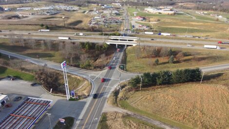
Major I-70 interchange project underway in Morristown
W.Va. statehouse lawmakers urge Capito, Justice to support ban on greyhound racing
CHARLESTON – Several Republican members of the West Virginia Legislature are encouraging the state’s two U.S. ...